
 CADASTERS AND
URBAN-RURAL PLANNING
CADASTERS AND
URBAN-RURAL PLANNING
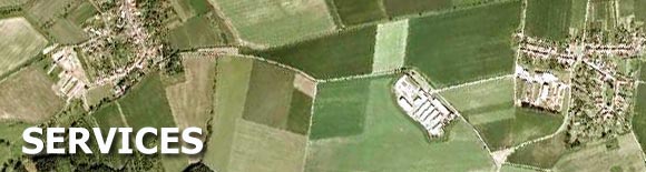
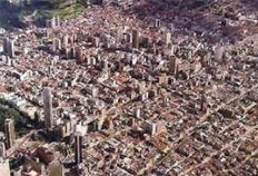
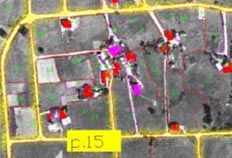
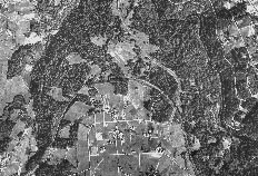
The IPDC develops cadasters of diverse nature, such as urban, rural, commercial, banking, mining, of hydrocarbons, ecological, forest and archaeological, among others.
By means of the appropriate use of the cadasters, it is identified the potentially interesting areas (tourist, commercial, green areas, of expansion, etc.) or problematic (crowded, polluted, in abandonment, etc.). With the appropriate analysis of these areas, we provide proper commercial solutions and we elaborate development projects for the Main Director Plans.
The IPDC possesses wide cadastral bases at national level, which allow the providing of current and precise information on any researches that are carrying out the different areas of its organization.
The IPDC has implemented diverse solutions for the location, representation, registration and administration of estates or entities, for that has professional experience and the latest technology. that it has all the stages of the cadastral development, including the geographical surveying, the cadastral survey, the census, the digital processing, the development of computer applications and the cadastral administration; being the main characteristic of this technology: the total systems integration, to facilitate the administration and the managerial administration.
GIS AND SYSTEMS
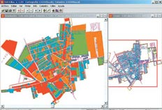
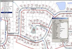
The IPDC has a special system area for the exploitation and administration of the information contained in the cadastral bases, for this it develops software and databases models to the measure of each project. It develops a variety of Geographical Information Systems (GIS) applications for several fields like banks, agriculture, energy, mining, distribution network, among many others.
IPDC is leader in GIS development, it possesses a wide experience in the implementation of different GIS in several fields, for this, it has diverse types of technological platforms and an own software, developed by its technicians, named Integrated Digital Cadaster (CDI).
The CDI possesses the latest technology to be installed in Internet and carries out all the necessary tasks to elaborate an integral cadaster, from the digitization and vectorization of the graphic information, to the development of complex digital applications and alphanumeric databases.
The CDI supports all type of digital processing and it manages mixed, graphic or alphanumeric databases in an integrated way. It can be installed through client- server networks and working stations designed according to the necessities of each operative area.
The IPDC is also dedicated to the elaboration of other digital information systems, including integrated databases and collection and tributary systems.
ENVIRONMENT
The IPDC is qualified to develop the most complex researches and projects of environmental impact that bear to the most appropriate solution in the environmental problem, regardering the forecast of effects on the natural system, its qualitative and quantitative valuation, and the formulation of actions to minimize the negative impacts and to optimize the positive ones.
The area of Environment of the IPDC possesses wide experience in the elaboration of Preliminary Evaluations, EIA, Base Lines, PAMA, among others. For that, the IPDC has the due current authorizations of the following entities:
- Ministry of Energy and Mines (Chapters of Energy, Mining and Hydrocarbons)
- Ministry of Housing
- Ministry of Transports and Communications
- Ministry of Agriculture (Inrena)
Among the main environmental projects are:
Electric Sector: It includes diverse topics, regarding: lines of distribution (local visual impacts, avifauna damages electrocution), transformation centers (noises and vibrations, residuals), substations (contamination and waste), central hydroelectric (modifications of the natural régime of water, control of the physical-chemical parameters and effect barrier for fauna), etc.
Mining Sector: It includes diverse projects that seeks to define the balance between the investments and the controls about the contamination of the environment, solving topics like: mining effluviums to rivers and courses of water, sour waters, production of residuals, washings, and alteration of the landscape, among others.
Hydrocarbons Sector: It includes different oriented projects to solve problems related to the necessity of obtaining precise information to confront environmental risks generated by the exploration, extraction and transport of hydrocarbons.
Transport and Communication Sector: It makes researches for evaluations of road infrastructure, contamination, measurement of radiations of magnetic fields, Evaluations of emissions and waste, EIA of facilities and nets, among other projects
Infrastructure and Housing Sector: It carries out oriented researches to preserve a healthy urban and rural habitat, among them can stand out, researches of soils, EIA of factories, deposits and residence units, researches of protected areas and green areas, elimination of waste, stability of banks, among others.
Natural Resources: It includes classification plans of the natural resources for their use and administration, development of restoration projects and environmental integration, continuous advising to the reservations and national parks, etc.

SURVEYS AND
SOCIOECONOMIC RESEARCHES
The area of Surveys of the IPDC possesses wide experience in the realization of quantitative and qualitative researches at national level. It has a professional team of first level and with the appropriate technological infrastructure to carry out diverse researches that we can mention:
|
|
It also carries out socioeconomic researches that have as objective to analyze the social and economic profile of a certain environment, among these researches they are: demographic researches, impact evaluations, researches of sustainability, educational evaluations, project analysis, among many others
To achieve this the IPDC, possesses a wide organization and a net of national offices that permit to carry out surveys in a record time and with the highest standards of quality and precision thanks to the facility of professionals specifically qualified in the following positions:
|
|
It also possesses the technological infrastructure to carry out personalized, phone surveys, by Internet or to depth, likewise, for the collection of data in field and the digitization of results.

Training
One of the company policies that is most applied is the permanent training of his technical and administrative personnel. Likewise, it qualifies the personnel of public and private institutions in different types of activities.
In such a sense a series of programmed courses are taught, as the "Graduated in Urban Cadaster", or not programmed, such as those that are organized in different areas of systems for those that it is being developed a project. Among some of the courses that are taught are:
 |
|
Tax Collection.
In this field, the IPDC carries out a series of own tasks of the cadastral function, with the purpose of contributing fundamental elements for the economic planning of a modern state. These tasks go from the scientific description of the qualitative and quantitative characteristics of the property origin of a certain territory, until the elaboration of complex detection systems and fiscal collection.
Everything constitutes as an important support for the municipalities, since it facilitates the objective determination of the payment obligations that they impact in the property and of the operations and process about it, they are carried out.
 The yield of the collection will depend in great measure of the efficiency
of the cadastral function, which will be determined by the appropriate
conjugation of the diverse factors of technical, administrative and
juridical nature, that the IPDC offers in each of the basic cadastral
functions.
The yield of the collection will depend in great measure of the efficiency
of the cadastral function, which will be determined by the appropriate
conjugation of the diverse factors of technical, administrative and
juridical nature, that the IPDC offers in each of the basic cadastral
functions.
Geographical
Location, Delimitation and Monumentation.
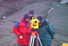
The IPDC possesses the necessary equipment to locate any cadastral unit geographically with the employment of such modern instruments as the GPS and the satellite images. The IPDC possesses the concerning information to identify the boundaries of areas and polygons that require to be defined, accurately to determine the predial, districtal, provincial or departmental boundaries and to be able to solve the conflicts by this way the boundary conflicts that there are in the country.
 To trace the definitive boundary of a place the IPDC carries out geographical,
historical, social and economic researches of character, related with
the areas that intervene, being able to determine from several aspects
the real relationship that there is with the place and this way to sustain
the research that will be presented before the public in charged instance.
To trace the definitive boundary of a place the IPDC carries out geographical,
historical, social and economic researches of character, related with
the areas that intervene, being able to determine from several aspects
the real relationship that there is with the place and this way to sustain
the research that will be presented before the public in charged instance.
Reparation and
Titling
In this field, the IPDC possesses specialized personnel to carry out the tasks of physical and legal reparation, as well as, to propose diverse solutions for the problem of the urban-marginal areas, including the legal tasks and the generation of the information that will help to carry out the titling of estates with effectiveness.
 The IPDC makes activities related to the determination of the ownership
of each property, which has been previously individualized and physically
cleaned up, using for this the cadaster of the area. It is also carried
out the search of the register records and extra registers that they
are picked up during the census works and set up boundaries; in such
way that the enough information is obtained to be able to register the
property in the Public Registrations, either rustic, erial, rural or
native community land.
The IPDC makes activities related to the determination of the ownership
of each property, which has been previously individualized and physically
cleaned up, using for this the cadaster of the area. It is also carried
out the search of the register records and extra registers that they
are picked up during the census works and set up boundaries; in such
way that the enough information is obtained to be able to register the
property in the Public Registrations, either rustic, erial, rural or
native community land.
Digital Topography:
The IPDC carries out a series of topographical digital services as those of satellite positioning GPS, for mining concessions, determination of checkpoints for air pictures, surveying of boundaries of lands, location of roads, and other objects not considered in the maps.
The IPDC also provides GPS data for the public or private corporations, including geodesic points that allow the location of entities with census ends. For this it uses DGPS teams and Total Stations of the latest generation to achieve accuracy and quality in the required work
Inside this point it also carries out the following services:
 |
|
Other Services
 |
|

- Government
- Mining
- Infraestructure
- Communications
- Banking and business
- Agriculture
- Energy
- Hydrocarbons